Evolution of the Heavy Snow Event-
Water vapor imagery shows the important upper level features.
As the imagery loops, note that there are two disturbances in the northwest flow upstream from North Carolina. A loop of radar imagery shows an area of rain moving eastward from central North Carolina during the day on December 2, 2000. This rain was associated with the lead upper level disturbance and may have influenced the distribution of snow that followed in eastern North Carolina. The possible effects of the lead vorticity disturbance included pushing the coastal baroclinic zone seaward, initializing the development of the coastal low sooner, and precipitating what little moisture was over central North Carolina prior to the arrival of the more vigorous vorticity disturbance. All of these effects would potentially limit the occurrence of snow in central NC and shift the heavier snow farther eastward than might have otherwise been the case.
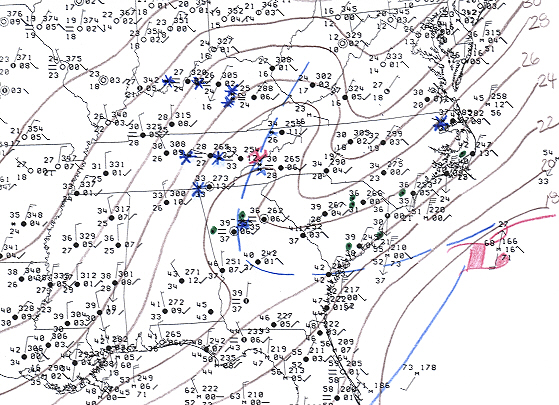
The magnitude and depth of the surface based cold air over North Carolina is not precisely known since the
RAOB at Greensboro NC (KGSO) was not available. In fact on December 2, 2000 at 12Z, a number of RAOB's
within or near the cold-air damming region were missing and potentially may have affected the model's
solution regarding the strength of the damming wedge. It is
reasonable to conclude that the strength of wedge did in fact limit the occurrence of precipitation
in the snow deficit areas of western and central North Carolina.
The water vapor imagery also revealed additional information. Note the decreasing definition in the vorticity maximum as it crosses the NC mountains. This may be signaling a decrease in the system's potential for lift. Indeed, the radar imagery shows the area of snowfall diminishing as it exits the mountains into the Upstate of South Carolina. Not only did this weakening lead to lesser precipitation amounts just east of the mountains, but it
also had implications on the potential for energy transfer from the upper system to the coastal surface low.
Energy transfer can be viewed as linkage between the lift generated by the upper level dynamics to the
converging low level inflow associated with the coastal low. The potential for linkage between the two systems
diminishes as the lift with the upper system lessens and/or as the convergent moist low-level inflow with the coastal low decreases. As the potential for energy transfers lessens so does the potential for precipitation,
especially in central North Carolina (damming region) where system interaction is most critical.
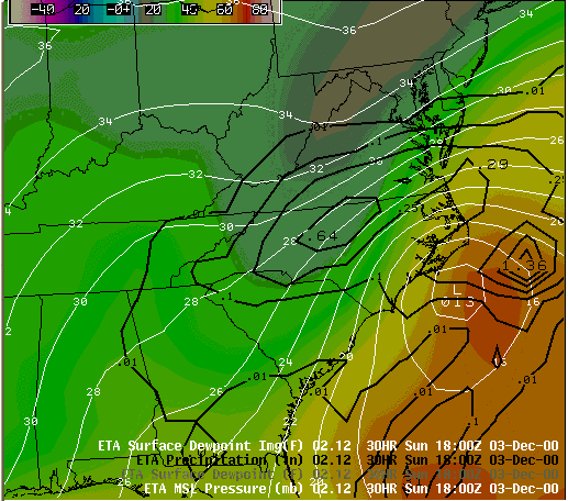
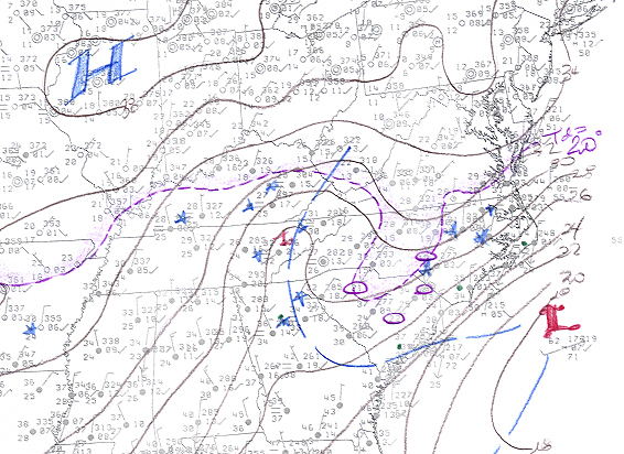
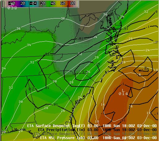
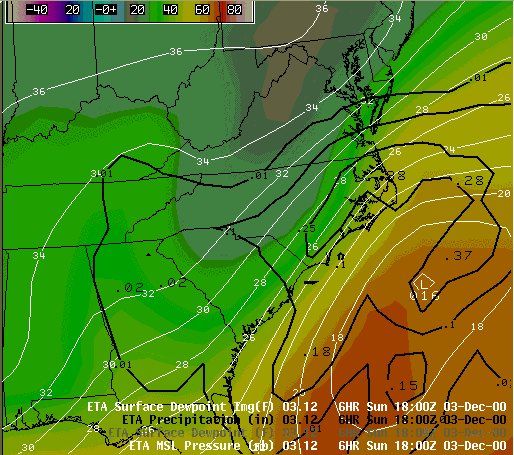
Relative to the observed low-level converging moist inflow, there are reasons to believe that the model's forecast of inflow was overdone. Note the ETA's forecast for the 850 MB flow associated with the coastal system. A 40 to 50 kt east-northeasterly inflow was predicted at 12Z December 3, 2000. But real-time analysis of VAD winds as the event unfolded found the 850 flow at RAH to be much less (20 kts) and showing a more northerly component. This too limits the potential for precipitation due to less convergence, less moisture, and less interaction between the two systems. The lack of a moisture laden upper level jet also likely limited the development of the coastal low.
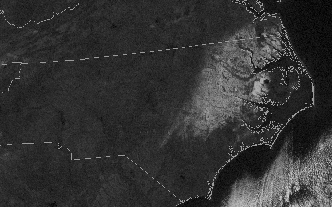
These noted inferences were used by RAH forecasters to trend down the initial forecast snowfall amounts in the western and central portions of the RAH CWA. A regional radar image from 0630Z December 3, 2000 shows the pattern of precipitation coverage as the event was beginning to unfold. A slow backing of the precipitation from the coast into eastern NC gave confidence to the forecast of heavy snow in the coastal plain. Note the weaker precipitation returns seen in central NC between the two main areas of precipitation. The enhanced precipitation elements seen within the two main areas were thought to represent convection that could possibly enhance and help to fill in the precipitation gap in
central NC. While confidence in potential interaction and energy transfer between the two systems was diminishing, the potential for latent heat release and its effects on the development of precipitation was enough to keep RAH forecasters committed to a significant snow event in central NC. Warnings in central NC were later dropped in an early morning update on December 3, 2000.
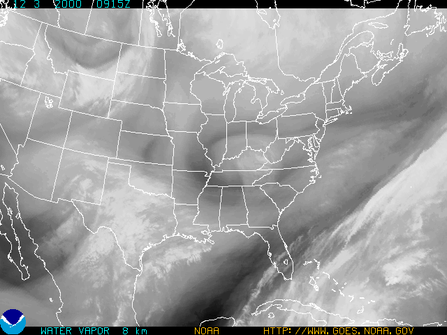
Water Vapor Image valid 0915Z Sunday 12/3/00
Loop of Water Vapor Imagery from 1815Z 12/1/00 through 2315Z 12/3/00
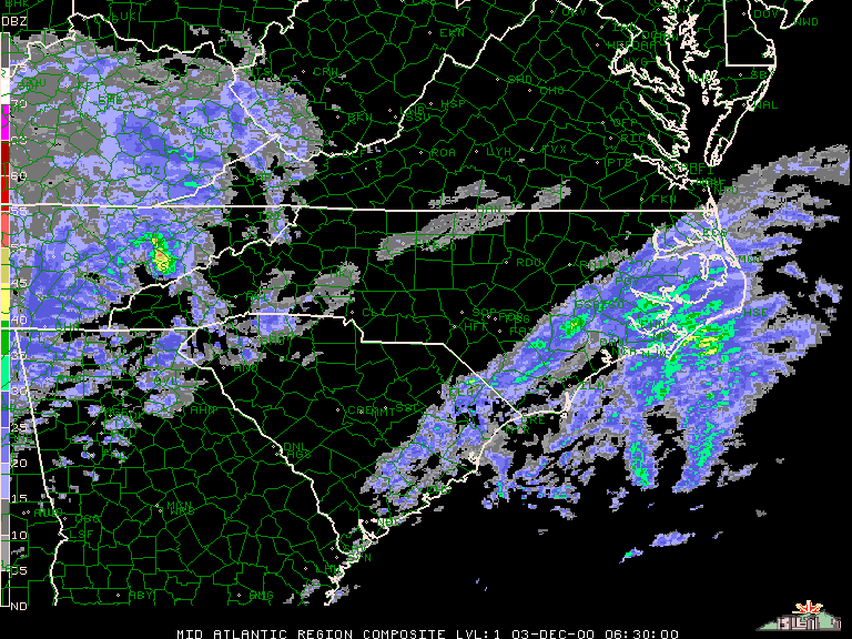
Regional reflectivity image valid 0630Z Sunday 12/3/00
Regional reflectivity loop from 1800Z 12/2/00 through 0800Z 12/4/00
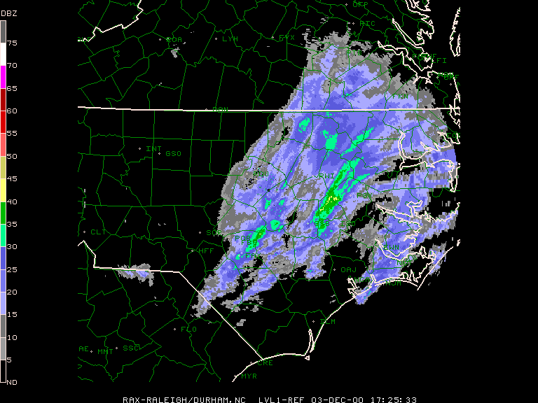
KRAX base reflectivity image valid 1725Z Sunday 12/3/00
KRAX base reflectivity loop from 0004Z 12/3/00 through 0304Z 12/4/00
|
|