|
|
Weather Processes
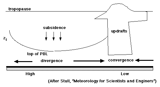
The PBL is where nearly all of our weather is produced. Temperature and pressure gradients caused by differential heating force the winds that drive air masses together producing warm, cold and occluded fronts. The lifting mechanisms produce the upward motion which causes the cooling necessary for cloud development to occur and precipitation to form. Though each of these processes is important in the role they play in the production of various weather events, these processes in the PBL are also important in the role they play in the transport, dispersion, and removal of pollution. Fundamentally, the study of boundary layer meteorology, better known as micrometeorology, looks at how the surface influences temperature, moisture, and velocity. This layer is relatively deep in clear weather (sunny skies) since the layer is warmed by radiation and the resulting convective turbulence creates a deep layer. Summertime boundary depths can be up to 1500 meters in the eastern US and up to 5000 meters in the desert region of the southwest.
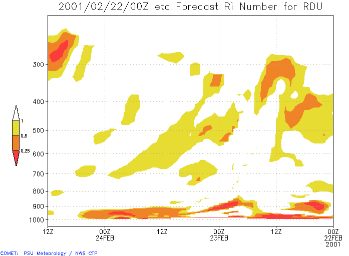
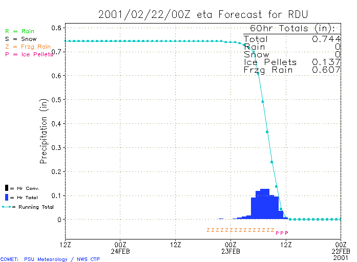
One of the measures of interest in micrometeorology is the amount of turbulence found in the boundary layer. The gradient Richardson number (Ri) is a frequently used calculated value that measures this degree of turbulence. Whenever this value is less than the critical Richardson number (Ric = 0.25), we can say that the air in the boundary layer is dynamically unstable and turbulent. A flow is said to be stable if Ri is greater than 0.25, and if it is less than 0.25 an instability may occur. This form of the Richardson number therefore provides important quantitative information on the relation between the stabilizing effect of buoyancy and the destabilizing effect of wind shear. Using the gradient Richardson number calculator, you can explore the mathematics of the Richardson number. You can also find Richardson numbers (and other data values) using the weather services data at Penn State University. For example, to find the Richardson number (Ri) for Raleigh-Durham, go to the link in this paragraph. Scroll down to "Regional Forecast Models" and then go to "Eta Time-Height (T-Z) Cross Section". From the pull-down menus, dial in "RDU", then dial in "Richardson Number" (or any other data value you would like to see) from the "Field" pull-down box. You will learn more about the Eta model in Module 8. For example, you can take a look at a Richardson chart for Raleigh-Durham, showing the values of Ri over several days from the surface (1000mb) to 200mb. You can also take a look at precipitation data for Raleigh-Durham. On the date of this precipitation graphic, RDU is getting freezing rain, ice pellets, and some snow.Confused? Have a question? If so, check out the Frequently Asked Questions (FAQ) page or send mail to the OS411 tutor (os411tutor@shodor.org) with your question! Report technical/content problems here |
|
|