| |
|
Puff Models: Architecture
There exist a number of puff models, such as MESOPUFF II, SCIPUFF, RAPTAD, MTDDIS, and CALPUFF. For this reading, we'll focus on CALPUFF as a representative puff model.
| The basic architecture of the CALPUFF model is shown in the graphic at right (click to see full-sized). In this graphic, there is a meteorological pre-processor, CALMET, that works to prepare raw meteorological data for the CALPUFF model. Data for CALMET comes from a variety of sources, including the relatively "standard" MM5 (mesoscale meteorological) model.
|

|
The graphic also shows three different dispersion models: the KSP (kinematic-simulation-particle) model, the CALPUFF dispersion model, and the CALGRID photochemical grid model.
Post-processing is done by PRTMET, the post-processor for meteorological data, and CALPOST, the post-processor for the main CALPUFF model.
A more detailed description of the CALPUFF modeling system is shown below:
Main Models
| CALMET |
3-D diagnostic meteorological model. |
| CALPUFF |
Non-steady-state transport, dispersion, and deposition model. |
Meteorological Preprocessors
| METSCAN |
Performs QA checks on hourly surface meteorological data. |
| SMERGE |
Combines and formats files of surface meteorological data
to produce a single file for use in CALMET. |
| PXTRACT |
Extracts precipitation data from NCDC data sets. |
| PMERGE |
Processes and merges precipitation data to produce a single
file for use in CALMET. |
| READ62 |
Processes NCDC upper air meteorological data to produce
upper air files for CALMET. |
| CALMM5 |
Processes MM5 meteorological output data and creates an
data file suitable for input into CALMET. |
Geophysical Data Processors
| TERREL |
Combines and grids terrain data. |
| CTGCOMP |
Compresses USGS land use data files. |
| CTGPROC |
Processes and grids land use data. |
| MAKEGEO |
Merges land use and terrain data to produce the geophysical
data file for CALMET. |
| PRELND1 |
Land use processor for ARM3 data set. |
| OPTHILL |
Develops hill-shape parameters for the sub-grid-scale
terrain option in CALPUFF. |
Postprocessors
| CALPOST |
Postprocessor for CALPUFF: performs visibility calculations,
averages and summarizes concentrations and deposition fluxes,
determines ranked concentration/flux/plume extinction values,
creates list files and plot files. |
| PRTMET |
Lists selected meteorological data from CALMET and creates
plot files. |
| APPEND |
Appends two or more CALPUFF concentration, wet flux, dry flux or relative
humidity (visibility) files. |
| CALSUM |
Sums and scales concentrations or wet/dry fluxes from two or more
source groups from different CALPUFF runs. |
| POSTUTIL |
Processes CALPUFF concentration and wet/dry flux files. Creates new
species as weighted combinations of modeled species; merges species
from different runs into a single output file; sums and scales
results from different runs; repartitions nitric acid/nitrate
based on total available sulfate and ammonia. |
Output for the model can be viewed in a variety of formats, including text- and/or graphics-based.
 |
The graphic at left (click to see full-sized) shows a sample run from the puff model. In this animation, the largest emitters of SO2 are shown by the blue dots. Running over a 10-day period, the animation shows the concentration of SO2 with this scale:
- Yellow=0.5 ug/m3
- Red=2.5 ug/m3
- Green=5.0 ug/m3
- Magenta=12.5 ug/m3
- Cyan=25.0 ug/m3
|
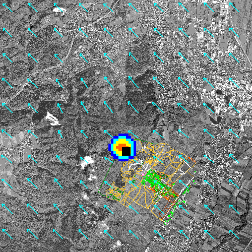
| Another interesting animated graphic at right (click to see full-sized) shows another sample run from a puff model. The blue arrows are wind vectors, showing the speed and direction of the wind. The animation shows the puffs of pollution (as concentrations) as they move from the point source (the black square) towards the downwind receptors. Notice the use of a photographic overlay of the modeling region. |
 |
The CALPUFF modeling system runs on a number of platforms, including Windows-based machines with a GUI (graphic user interface) input/output screen.
An interesting model description is available as a Adobe Acrobat PDF file. Of particular interest in this document is the "checklist" format of specific characteristics.
|
|