|
|
Cumulus and Cumulonimbus Clouds
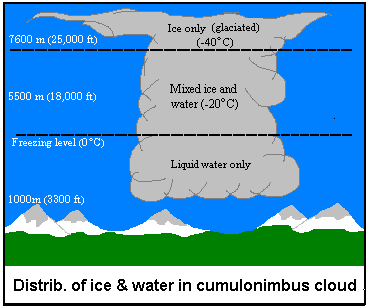
Cumulus clouds are the white puffy clouds that we commonly see on sunny, summer afternoons and are most often the type that form during the passage of cold fronts. Cumulus clouds are non-precipitating but can develop into the towering cumulonimbus clouds which produce heavy downpours and strong winds. These clouds are characterized by very strong updrafts, and they develop very rapidly, rising high into the troposphere. However, more often than not, cumulus clouds dissipate as quickly as they form. Due to their short life spans, they provide a moist chemically reactive environment for a short period of time. This allows reactions to take place before droplets evaporate, leaving behind newly formed compounds to linger and react once again. An example of this is the oxides of sulfur which react to form sulfates. Over the course of a summer afternoon, you may notice a haze developing. This is often the result of the concentration of sulfates increasing as cumulus clouds form and evaporate.
Cumulus and cumulonimbus clouds are good absorbers of long wave radiation emitted by the earth. They can, because of their thickness and larger water droplets, also reflect a lot of sunlight away from the earth. But, because they are generally scattered and do not blanket large areas , they do not have as much of an influence on the earth's heat budget as the next group, the stratus clouds.
Confused? Have a question? If so, check out the Frequently Asked Questions (FAQ) page or send mail to the OS411 tutor (os411tutor@shodor.org) with your question! Report technical/content problems here |
|
|