|
|
Grids and Time ZonesThere are a couple of other scales we want to mention before moving on to the next unit -- grid scales and time zoning. Gridding is important in many meterological models, and an understanding of time zones is necessary to interpret meteorological data that comes from National Weather Service (NWS).
GridsIn many meteorological models, a grid is used to represent weather data for an area. For example, one model may take information from one weather station location and consider it representative of the conditions in the atmosphere for a 100 square km block near that station. By using data from more and more locations to represent larger and larger areas, a grid can be built that covers an enormous area with a fair amount of accuracy. On the other hand, the smaller the area to be represented, the more detailed the information should be to insure a more specific and accurate model output. For example, let's say a model has a grid point spacing of 10,000 km. That means that each block covers 10,000 square kilometers. The model output would then give information for that cell that represents an area of 100 square km. In many models, the user has the ability to change the input resolution (grid spacing), thereby increasing the amount of input information needed, as well as the detail of output data.
Since you get more detail and a more accurate prediction with a higher resolution grid, then why not use a small grid size all the time? The problem is that with a small grid, enormous amounts of information must be put into the computer model to get a meaningful prediction. The more information you put in, the longer it takes the computer to give an output prediction. For a high resolution grid (25 km), covering the entire country, it might take several days to get back an output prediction for tomorrow. Such a high resolution model would be nice, but would be worthless for such an application. The hard part is trying to develop a model that accurately predicts the atmosphere and uses a grid resolution that is practical.
Time ZonesAs you probably know, the earth is broken up into 24 time zones. This is done for simplicity so that all people in a region can use the same time schedule. However, because meteorologists need data for the entire world simultaneously, observations and measurements must be taken at the same time all over the globe. When does this happen? Six o'clock? Ah, but 6:00 in Chicago is not 6:00 in Rome. So meteorolgists use UTC, which stands for Universal Time Convention (formerly called GMT, or Greenwich Mean Time) . This is the time along the Prime Meridian, or 0° longitude. It was called Greenwich Mean Time because the Prime Meridian goes through Greenwich, England. Meteorological soundings (using radiosondes) are taken twice daily at 00 and 12 UTC. This corresponds to 7:00 am and 7:00 pm, respectively, in Eastern Standard Time. Other meteorological measurements record the UTC time, also. For instance, the next time you look at a Dopplar Radar image on TV, you might notice that the time says something like 14:45 UTC. This is not your local time, but the international time. Often, you will see a "Z" instead of UTC. This "Z" stands for Zulu time, which originated in the military and is often used on weather maps and radars. Zulu time is equivalent to UTC. For conversion, always remember to subtract 5 hours for Eastern Standard Time (four hours for Eastern Daylight Time). By understanding the UTC times at which measurements are taken, it is easier to understand the structure and motion of the atmosphere. The reporting time for surface weather observations is on the hour, and represents the conditions that occurred during the previous 5-10 minutes.
Confused? Have a question? If so, check out the Frequently Asked Questions (FAQ) page or send mail to the OS411 tutor (os411tutor@shodor.org) with your question! Report technical/content problems here |
|
|
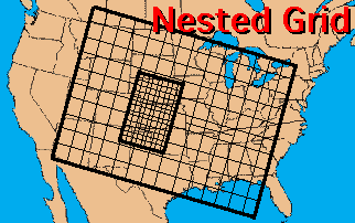 In addition, many models use what is called a nested grid. A model may have a low grid resolution for a large area (say, 200 km grid point spacing, covering an area from southern Canada to Florida). Then, it has the ability to take a higher resolution grid (say, 25 km) and nest it over a region of particular importance (such as a frontal zone over the Rockies). This method allows information to be included for a large area, but then allow lots of information in an area where it is needed.