| |
|
Surface Maps
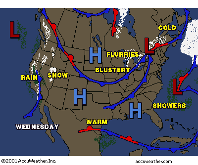
| Certainly some of the most useful meteorological tools and products are the wide variety of maps that are produced from atmospheric readings (soundings) by a variety of organizations, such as the National Weather Service (NWS). The map at the right is a "typical" type of map presented on the 6 o'clock news. This map, in addition to the text-based notation ("flurries", "rain", etc.) shows the location of cold fronts (blue lines) and warm fronts (red lines) as well as the locations of high ("H", or "highs") and low ("L", or "lows") pressure systems. In addition, this particular chart shows the location of areas of precipitation. These charts are designed to be simple to read but convey a fair amount of information to the television consumer about the weather situation. |
Copyright@2000 AccuWeather, Inc.
|
Surface Maps
Suface maps are detailed outlines of the current weather in an area. A single surface map of the conitinental United States can contain reports from over 500 stations at one time. Reported hourly from airport stations or automated observation platforms, these maps exhibit the readings (such as temperature, pressure, wind speed and frontal locations.
There are a variety of surface maps produced, all of them available via the Web. As before, one of the best sites for obtaining these maps is the Unisys Weather Surface Map generator. From this Web location, you can "dial in" a wide variety of surface maps for viewing and/or printing.
Four general types of surface maps -- the composite surface map, the surface weather depiction map, the frontal location map, and the regional data map -- are presented below with a short description and a sample map (click on the image to see the full-sized graphic):
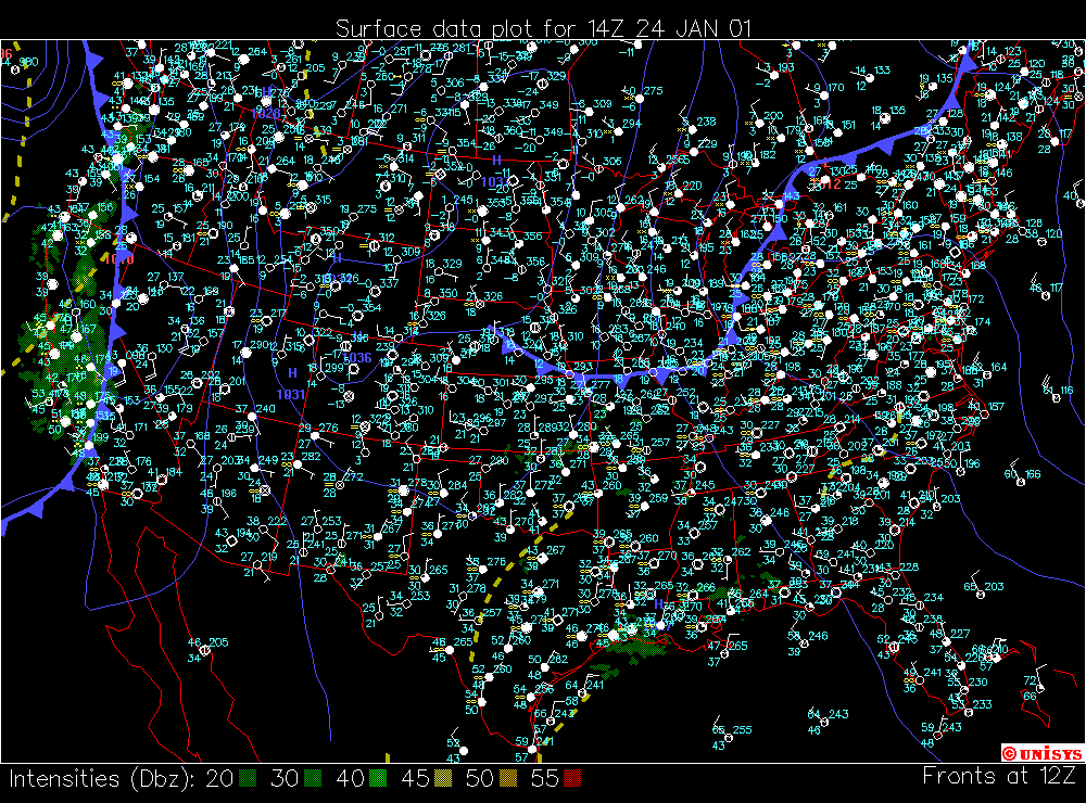
Composite surface map: produced hourly (normally at 30 minutes past the hour), these charts are exactly as the name describes -- composites of a tremendous amount of information! These charts show approximately five types of data:
- a radar summary
- surface data for specific meteorological "stations"
- the location of fronts
- flight rules for the aviation community
- pressure contours
For lots of detail on each of these items, we recommend visiting Unisys's surface map Web pages. |
Note!This is a large image!
|
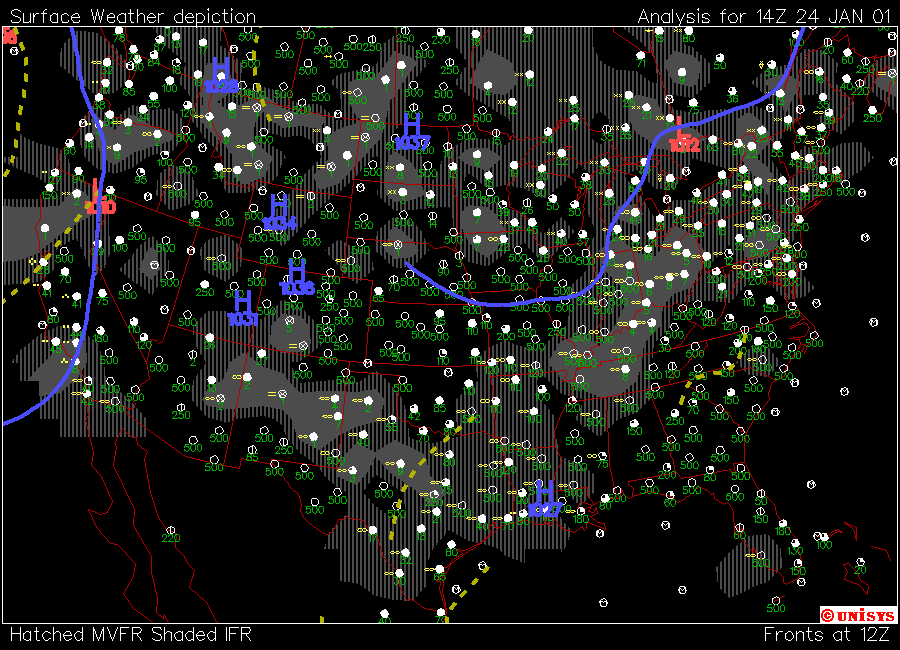
| Surface Weather Depiction Map:
These charts are composite maps with the aviation community in mind. They show three types of data:
- flight rule depiction: whether conditions in a certain area are VFR (visual flight rules, meaning pilots navigate visually), or IFR (instrument flight rules, "blind" navigation through the use of cockpit instruments
- depiction data: showing data such as cloud cover, present weather, and cloud ceiling
- location of fronts: shown as bold lines on the chart
|
|
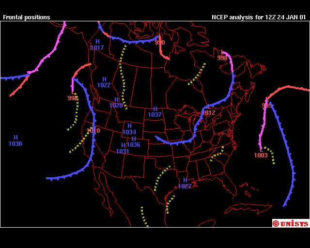
| Frontal Location Plot:
These charts, as the name suggests, show the locations of fronts, including cold, warm, stationary, occuded, and "troughs". High and low pressure systems are also shown with the associated letter (H or L) and the pressure in millibars (mb) shown beneath the letter. |
|
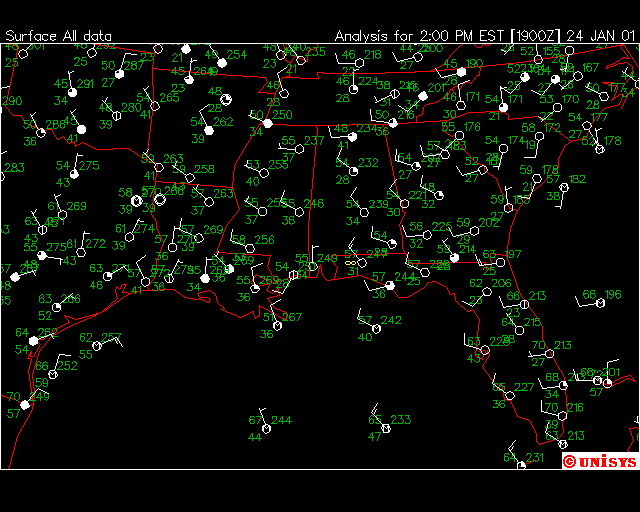
| Regional Data Plot
These charts show the data for individual stations in a particular region. Each station uses the same symbols as are found on meteorgrams. You can also look at Unisys's surface map Web pages for more detail on these symbols. The graphic at right shows the regional data map for southeastern United States. |
|
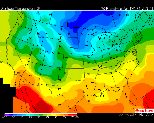
| Contour plots:
In the surface plot category, there also exist a wide variety of contour plots, showing variables such as temperature, dewpoint, relative humidity, and the like. The chart on the right shows temperature contours for the United States. Notice the legend at the bottom of the chart, showing the color-coding used for the various temperatures. |
|
Confused? Have a question? If so, check out the Frequently Asked Questions (FAQ) page or send mail to the OS411 tutor (os411tutor@shodor.org) with your question!
Report technical/content problems here
|
|